Geography
The Geography curriculum at Slade Primary School aims to provide our pupils with a strong understanding of geographical knowledge and discrete geographical skills, traits of resilience and growth mindset, along with exposure to life and learning experiences which our students may not otherwise have had.
Our provision is coherent and carefully sequenced, taking a knowledge engaged approach. Teacher’s use four key elements to underpin our curriculum: cognitive science, rich reading opportunities, ambitious life experiences and a commitment to our local community. Teachers use a variety of methods to achieve these goals, however the Slade non-negotiables will characterise every taught geography unit: knowledge organisers, retrieval of prior knowledge, clear reading opportunities, thinking maps and word exploration.
As children progress from EYFS to Y6, pupils will know more and understand more about their local area, the UK, Europe and the World. Children will learn about key geographical concepts such as place and space, land forms, the global economy and biomes and vegetation belts. Over time, pupils will become more skilled at being geographers, answering questions such as; what is it like to live in this place? What are the challenges of this environment? How have people changed this landscape over time? How is the culture of this place different to the UK and how have human and physical features shaped those differences?
Each geography unit begins with an exploration of the topic area, using atlases, maps and range of digital mapping tools. Pupils explicitly learn to locate places on a map, position items on a map, use symbols in a key, interpret scale, read climate graphs, identify locations using co-ordinates, interpret population data, identify elevation on relief maps and more. This builds on the learning in EYFS, where children begin to develop a sense of their physical world and the community around them,
Slade’s geography curriculum is necessarily prescriptive to ensure progression of skills. However, we also ensure that pupils’ knowledge of our locality and enrichment opportunities are also progressive.
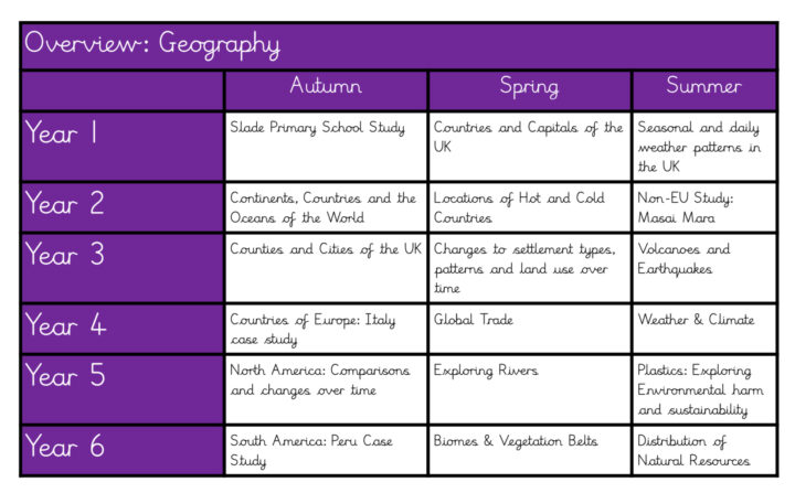
In year 1, pupils gain an understanding of the location and place of our school, using maps to explore the playground. In the Spring, pupils further their knowledge of location and place by studying the UK – its countries and capital cities. In the summer pupils study the UK’s weather patterns – learning about concepts such as weather and seasons.
In year 2, pupils delve further into the concepts covered in year 1. Pupils explore geography outside of the UK for the first time – learning about continents and seas through the medium of selected countries and their key characteristics. In the summer, pupils narrow this focus to look at just one non-European culture. Back to the spring, pupils then use their prior knowledge of weather to study hot and cold countries of the world, learning about the poles and equator – teachers aim to impart the understanding of the relationship between proximity from the equator and temperature.
In year 3, pupils build on their prior knowledge of countries, capitals and continents to study counties and cities of the UK, particular importance is given to the context of our school and local area, so pupils narrow their focus in the West Midlands and Birmingham as the unit develops.
In year 4, pupils conceptual knowledge takes on a new dimension, studying the country of Italy, its characteristics including governance and industry before looking at the concept of trade on a global scale. In the autumn, the pupils show how much their understanding of the concept of weather has progressed, studying the weather cycle and how it affects the human and physical features of a place.
In year 5, students study North America, focusing on human and physical comparisons with the UK and changes through time before delving deeper into physical geography by investigating rivers. Students end year 5 with an understanding that human features of geography such as industry have impacted upon the physical features of our world such as the health of the seas and sky.
In year 6, the pupils progress in depth from autumn till the summer by first studying the country of Peru, then focusing on its physical features- biomes and vegetation belts – before its human features – natural resources and distribution.
Pupils enrichment, engagement with the community and life experiences develop over their primary school education. For example, in Y2 pupils go out of school and explore Slade road, in Y4 pupils explore Stockland Green and in Y6 pupils complete a local study of Birmingham’s Jewellery Quarter. We have been lucky enough to make great local links with the community, so much so that pupils present their learnings to MP’s, collect data from community weather stations and receive guest speakers from geography societies.

